Most genealogists are aware that in exactly one month the 1950 U.S. Federal Census will be released to the public (April 1, 2022). Per the Census Bureau, each census is released 72 years after it was taken. Not only is it fun to find family members in the census, there are usually amazing nuggets of information waiting to be uncovered.
Last week my local genealogy society, Marin County Genealogical Society, was lucky to have Stephen Morse present “Getting Ready for the 1950 Census: Searching with and without a Name Index”. It was an excellent presentation. You can view a video of the presentation under the Recorded Lectures page at the One-Step Webpages by Stephen P. Morse site.
As Steve Morse explains in the video, in order to browse the 1950 Census images when they are released, we will need to know where our family lived and the Enumeration District (ED) that address belongs to. The One Step website is the place to go once you have an address. It has an amazing tool that decodes the Enumeration District number. There are several other tools including the ED descriptions and ED maps.
The ED Maps helped me to find a forgotten neighborhood!
I know my grandparents were married a couple of months after the 1950 Census was taken. My grandmother told me the story of how she was set up on a blind date with my grandfather while they were both living in Wichita, Kansas. This story helped me to find City Directory entries for both of my grandparents in 1949 in Wichita.


My Grandma’s address worked like a charm in the One Step ED Finder page. It gave me three possible ED numbers. Using the ED descriptions, I was able to narrow this down to the correct Enumeration District.
My Grandpa’s address was a little tricky and led to the discovery of a lost neighborhood. 303 Beechwood Drive does not exist today in Wichita, Kansas. I tried to use street name change websites to identify the street. Bust! My next step was to google the address. Bingo! I found an article and audio file from KMUW89.1 (Wichita Public Radio) titled “Wichita’s Forgotten Neighborhoods“. Time to learn some local Wichita history!
During WWII, temporary housing was created in Wichita to house the many workers at the aircraft factories in the city. Two of the three neighborhoods still exist. The third neighborhood was Beechwood. Five hundred housing units were created. There were approximately 1000 people living in the neighborhood at the time my grandfather lived there. It was dismantled in 1951 and turned into a “grassy area”. Google Maps indicates there is now a YMCA and office buildings in the former neighborhood. There seems to still be large grassy areas between the buildings.
Once I had this new information, I used the description of Beechwood’s location in the news article and matched it up to the Enumeration Maps. The first map I pulled up was for the city of Wichita. I was excited to see the name Beechwood in the area I was looking for. It is marked with a yellow arrow below.
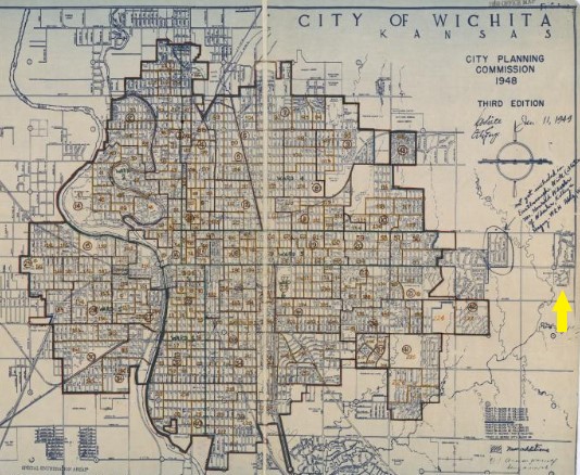
Since Beechwood fell outside of city lines, I next pulled up the Enumeration Map for the county of Sedgwick, Kanas

Beechwood falls into the yellow box to the East of Wichita. This reads 87-40 to 87-43 (ED numbers) See Urban Fringe Map For Detail. This led me to the map that identifies the Enumeration District I need to find my grandfather in the 1950 census.

Wichita is still heavily involved with the aviation industry. Textron, Learjet, Airbus, Boeing, the US Airforce and Beechcraft all have a presence in Wichita today. There are 3 airports within today’s city limits. The Beechcraft Airport in the above image is now called the Beech Factory Airport, honoring its roots as several aviation companies are located there.
It was so much fun to find more information about my family, the places they lived, and the forgotten neighborhood of Beechwood as I was prepping for the 1950 Census. I am excited to find the 1950 Census entry for my Grandpa. Browsing the images will hopefully paint a better picture of who was living in the neighborhood and what their lives were like.
A huge THANK YOU to Stephen Morse and Joel Weintraub for all the work they do at the One Step webpages. I would not have been able to find all of this without the amazing tools they have created.